
|
|

|
|
|
Cattail Cove State Park |
|
|
Event Notes |
|
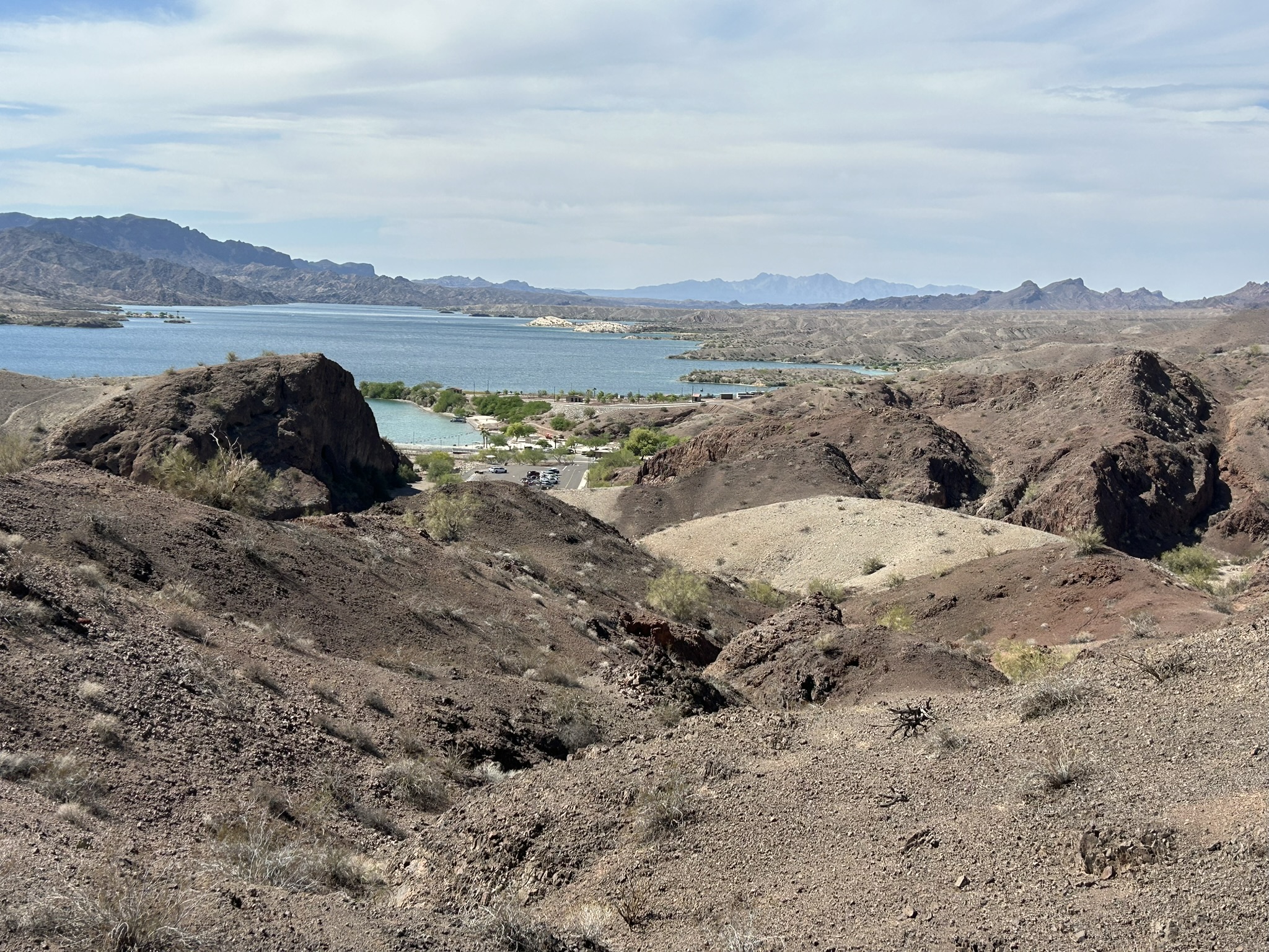
Thanks to everyone who signed up for our 2025 Sonoran Desert Navigation Games at Arizona's Cattail Cove State Park. We're excited that you've decided to join us for a day of navigation fun at another scenic Arizona location. If you've never visited Cattail Cove State Park, you're in for a treat. The park has amenities to make your stay comfortable while the area has a vast amount of rugged terrain to explore. Oh, and also, there's the lake. We hope you enjoy your visit.
Below are notes for events. Please read the notes carefully as they include important information about your race. Let us know if you have any questions.
The following sections are included below:
1. EVENT LOCATION
2. MISCELLANEOUS
3. SCHEDULE
4. CHECK-IN
5. MAPS, COURSE STATISTICS
6. SCORING
7. GEAR LIST
1. EVENT LOCATION
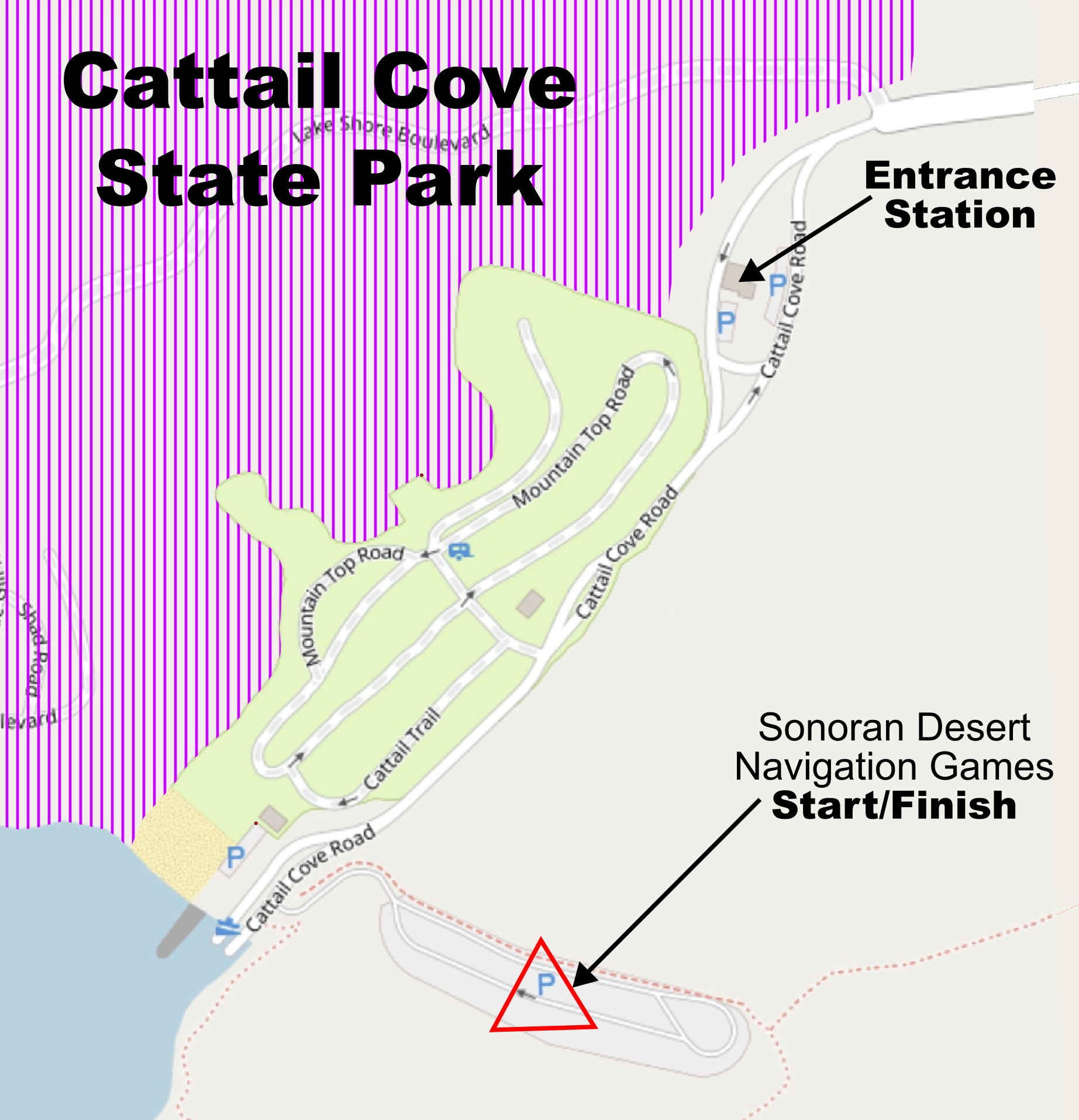
The start/finish for all events is at the overflow parking area at the southeast part of the park. After passing the entrance station, continue towards the lake. Just before driving your vehicle into the lake itself, turn left on the paved road to the overflow parking area.
| Google Placemark: | https://www.google.com/maps/place/34.350412, -114.167830 |
| Directions to Cattail Cove: | https://gphxo.org/Locations/CattailCove_Directions.htm |
2. MISCELLANEOUS
- Weather - Heat Wave Average highs at Cattail Cove in mid-April are in the low 80's F. The lows can drop into the mid-40s F. Unfortunately, it looks like we're in for a heat wave this year. We can expect a high around 95F on Saturday. The low Saturday morning will be ~60F. Please plan accordingly. Bring plenty of water. Hydrate regularly. We'll have several water drops and at least one manned location with food and drinks on the course.
- Entrance Fee There is an entrance fee to enter Cattail Cove State Park. If you arrive Saturday morning, it's likely you'll arrive before the park entrance booth opens at 8:00 AM. If you're camping in the park, you will not have to pay an additional entrance fee. If you camp overnight Friday night, the camping technically only allows you to stay in the park until 12:00 PM, so technically, you should pay for the Friday night camping then pay for Saturday in the park. We'll let you work things out with your conscience.
- Snakes Yes, things are warming up. Yes, there are snakes. We suggest you pay attention and avoid the snakes. We've walked the desert setting 100's of events over the years. We've about stepped on 6 snakes total over 20 years. It's unlikely that you'll see a snake, but it's possible. Pay attention and be careful.
- Itchy Vegetation We haven't encountered poison ivy in the area, but scorpion weed may be present near the lake, as well as other plants that cause skin irritations.
- Thorny Vegetation The vegetation surrounding Cattail Cove is sparse. Most of the terrain is runnable, at least in the flatter areas. Vegetation is more abundant in the washes and along the lake shore. There are some thorny plants (cactus, cat claw, etc.), but you're mostly able to see the thorny plants and avoid them. If you do end up with an injury caused by a thorny plant, we'll assume you did it on purpose so we feel sorry for you.
- 50 Meter Limit Teammates in all events must stay within 50 meters of each other at all times.
- Visit Controls Together Teammates in all events must visit controls together. You are not allowed to send one teammate to visit a control while other members of the team take a nice break.
- Target Shooting We didn't encounter any shooters when we set the course. However, there was evidence of shooting at many places on the course. Keep this in mind as you navigate between points. We tried not to place controls near shooting areas, but we can't guarantee you won't encounter a shooter. If you encounter shooters, try to communicate with them to let them know we're there, or just avoid them completely.
- Dispersed Camping There is dispersed camping throughout the area. You should simply avoid the campsites and give the campers their space.
- Controls on Trees and Bushes We hung many of the markers on shrubs and trees in the area. Depending on the angle of approach, the markers may or may not be visible in the mapped location. If you're sure you're in the correct location marked on the map, you may need to look on the opposite side of the vegetation.
- Steep Terrain, Loose Rock Just to warn you, there are areas on the course that are quite steep and covered with loose rock. Rather than attacking a steep slope and risking sliding back down, we suggest you travel around the steep areas and stay in drainages that are less steep.
- Game Trails We followed a number of game trails when we set the course. The trails were handy, but aren't visible from satellite views. The maps do not include game trails.
- Unmapped Features The area covered by the event is quite large. Given the amount of time spent on the course, it wasn't feasible to create an orienteering-quality map of the area. There are many unmapped rocks, cliffs, roads, etc. The contours are based on a 1-meter resolution point cloud generated from a sterophotogrammetry survey. The 5m/10m contours are quite accurate. We tried to place controls in features easily identified by the contours.
- Manual Punching We are not using electronic timing. We have manual punching for all our destination markers. We'll give you a control card at the start of the event. You'll register your visit to each destination by punching the appropriate spot on the control card.
- Cell Phones We encourage you to travel with a cell phone. There is minimal cell phone coverage throughout the course, but you could get lucky. You may take pictures with your phone or use it for emergency communication. You are not allowed to use your phone for navigation. Use of navigation features on your phone will result in disqualification.
- GPS Trackers You may use a GPS tracker (standalone GPS device, GPS watch, etc.) to record your route during the event. You may not use any type of GPS for navigation or measuring distance. Manual bike odometers that measure distance based on wheel circumference are allowed. Barometric altimiters are allowed. Bike odometers that measure distance using GPS are not allowed. Navigation or measuring distance with a GPS unit will result in disqualification.
- Disappearing Control Bags We placed many of the destination markers in the field last week. We can't guarantee that the orange and white bags remain where we left them. If you get to a place where you think the bag is missing, look for a piece of orange tape nearby. We placed the tape in trees/bushes near the bags and wrote a three-letter word on the tape. Record the three letter word on your control card if the bag has disappeared.
- Aid Stations We'll have at least one manned aid station on the courses. The manned station is accessible for all courses. We'll also have several control locations with water available. It will be hot in the afternoon. Please take advantage of the aid station and the water we've provided.
- Restrooms, Showers We'll be in a state park, so the restroom and shower facilities are excellent. Outside the park, you're on your own. You'll have most of nature's finest desert terrain to do whatever it is you need to do.
- Early Race Termination If you need to leave the event early for any reason, please sign out with race directors at the start/finish. It would be really bad if we called out emergency services and spent time looking for you only to find out you decided to go home two hours earlier.
- Avoid Crossing Highway AZ-95 The main highway through the area is AZ-95. The highway is very busy during the day. When you need to cross to the other side of the highway, we ask you to use one of the many drainage culverts that are easily large enough to walk through.
-
No mandatory mode of transportation (Adventure Races Only) For the adventure races, there is no mandatory mode of transportation, except for the water controls which can only be reached by watercraft. You can travel by foot, bike, or watercraft to all other controls. It's your choice.
For controls on the foot map, we guarantee it will be more efficient to visit most of the controls on foot. There may be one control on the foot map where using a bike would be helpful. For the controls on the bike maps, half of the controls could be more efficient to visit on foot. The other half are distant controls where using a bike is likely much better. Again, you get to plan your own adventure, so hike, bike, or paddle, you're welcome to use your favorite mode of transportation.
- Cattail Cove, Surrounding Ground Off-Limits The entire area northwest of the main park road is off-limits to foot or bike travel. The park is expanding, so there's a large construction area to the northwest. The off-limits area is marked with the purple cross-hatch symbol on the maps. You are not allowed to travel by bike or on foot into the off-limits areas.
- Bikes on Roads and Trails Only When traveling by bicycle, you must remain on an obvious paved road, improved gravel road, jeep trail, single-track trail, or open drainage at all times. You are allowed to ride your bike through the sandy washes. You are not allowed to ride cross-country between points. The desert is fragile, and riding cross country will leave a trace that could take decades to disappear.
- Paved Roads Except for a short section of AZ-95 to the northwest of the park entrance, you are not allowed to ride along the highway. The highway gets very busy during the day. We avoid dangerous situations by prohibiting riding along the road. When you need to cross to the other side of the highway, we ask you to use one of the many drainage culverts that are easily large enough to walk through with your bicycles.
- Helmets Required (Bike travel only) Helmets are required while you travel on your bike. Travel by bike without a helmet will result in disqualification.
- Sand The bikeable portions of the course are easily 50% in sandy washes. We suggest you take this into consideration when choosing the type of tires you use. If your tires are too narrow, you'll spend a substantial amount of time walking your bike.
- Bike Lock The bike controls are all within 200 meters of a road or trail. There will be cases where you need to drop your bike and hike for a short distance to reach the control. While we didn't encounter others when we set the course, you should lock your bike if you're concerned about theft when you hike to the controls.
- Not Mandatory You are not required to travel by watercraft during the race. However, three controls on the northwest side of the lake are only accessible by watercraft. To encourage watercraft use, the three controls on the northwest side of the lake are worth 3 points apiece. All other points (20 on foot map, 14 on bike map, and 3 on watercraft map) are worth 1 point apiece.
- Inflatable Only Only inflatable watercraft are allowed. This can include inflatable pack rafts, inflatable kayaks, inflatable paddleboards, etc. No hard-shell watercraft are allowed.
- Inflate before the Pre-Race Briefing You're welcome to leave your watercraft deflated until you get to the water's edge, but we've designed the course so you will likely inflate your watercraft before the event starts, then carry your inflated watercraft to the water. The minimum you'll carry your watercraft is ~500m. When setting the course, we carried our watercraft ~2km. Depending on your route selection, you can choose to paddle more and portage less.
- Human-Powered Only Watercraft must be propelled by human power. No sails allowed. No motors allowed. The most common means to propel the watercraft is with oars or paddles. You're also welcome to strap on flippers and flutter-kick your way across the lake if you like.
- No Transport by Bicycle You're welcome to carry your inflatable watercraft with you on your bike, but we've designed the course so it isn't necessary. You will likely only travel between points by paddling or by carrying your watercraft as you hike.
- PFDs Required You must wear a PFD whenever you're paddling your watercraft. Travel by watercraft without a PFD will result in disqualification.
- Sign Out/In Before you start traveling by watercraft, we require you to sign out with race directors at the start/finish. You are also required to sign back in when you are finished with the paddle section. We want to know when you intend to be out on the lake and when you have successfully returned. We will not include points from the watercraft map for any team that fails to sign out or sign back in.
Adventure Racers
Bikes
Watercraft
3. SCHEDULE
Daylight Period
Sunrise: 6:08 AM
Sunset: 7:08 PM
Civil Twilight Start: 5:43 AM
Civil Twilight End: 7:32 PM
| Event Summary | |||||
| Time | Event(s) | Location | Directions | Google Maps |
Safety Plans |
| Saturday, Apr 12, 2025 | |||||
|
12-Hour Adventure Race 12-Hour Rogaine 6-Hour Adventure Race 6-Hour Rogaine 3-Hour Rogaine |
Cattail Cove Overflow Parking |
To State Park | Placemark | Safety Plan | |
| 5:43 AM | Civil Twilight Begins | ||||
| 6:00 AM |
Check-in opens for 12-hour events. Location: Cattail Cove State Park, Overflow Parking. |
||||
| 6:08 AM | Sunrise | ||||
| 6:30 AM | 12-Hour Events: Mandatory Briefing | ||||
| 7:00 AM | 12-hour Events: Mass Start | ||||
| 7:30 AM | 3/6-Hour Events: Mandatory Briefing | ||||
| 8:00 AM | 3/6-Hour Events: Mass Start | ||||
| 11:00 PM |
3-Hour Rogaine Course Closes. All 3-hour participants must be off the course by this time. |
||||
| 2:00 PM |
6-Hour Rogaine Course Closes. All 6-hour participants must be off the course by this time. |
||||
| 7:00 PM |
12-Hour Courses Close. Late penalties apply for those arriving after the 7:00 PM cutoff. |
||||
| 7:08 AM | Sunset | ||||
| 7:30 PM | Arrivals after 7:30 result in disqualification | ||||
| 7:32 PM | Civil Twilight Ends | ||||
4. CHECK-IN
All participants must check in before their race at the event start/finish located at the overflow parking at the southeast part of the park. In addition to asking participants to sign in, we'll also hand out control cards for the events. During the events, at each "destination marker" (control), participants use a manual punch to record their visit to the control location.
After check in, participants must attend a pre-race briefing at 6:30 AM (for the 12-hour events) or 7:30 AM (for the 3/6-hour events). Please be on time for the mandatory briefings. We'll hand out maps and provide last-minute instructions at the mandatory briefing.
Special Instructions for Adventure Race Events
Please prepare the following for your check-in:
-
Declare if you plan to use a mountain bike for travel during parts of your race.
Note1: You are not obligated to actually use your mountain bike if you declare your intention. We simply verify your equipment at check-in. -
Declare if you plan to travel by inflatable watercraft during parts of your race.
Note1: If you do not plan to travel parts of the race using an inflatable watercraft, we will mark off the watercraft controls on your control card. You are not allowed to travel to the water controls on foot or by mountain bike. You can only access the watercraft controls inflatable watercraft.
Note2: You are not obligated to actually use the inflatable watercraft if you declare your intention. We simply verify your equipment at check-in. - If traveling by inflatable watercraft, each member of the team must show their PFD and inflatable watercraft at check-in.
- If traveling by mountain bike, each member of the team must show their helmet at check-in.
- If participating in a 12-hour event, you must show a working light source at check-in.
5. MAPS/COURSE STATISTICS
The Sonoran Desert Navigation Games at Cattail Cove consists of the following sections:
| Section | # Maps | Paper Size | Scale | Contour Interval | Straight-Line Distance | Climb | # Controls | Notes |
| Watercraft | 1 | Letter/ Landscape |
1:15,000 | 10m | 8.4km | 0 | 5 |
Note1: All watercraft controls are optional. You may visit as many or as few of the watercraft controls as you like. Note2: The five water controls are only accessible by watercraft. |
| Foot | 1 | Tabloid/ Landscape |
1:10,000 | 5m | 13.0km | 1013m | 20 |
Note1: For the 6-hour and 12-hour events, you are welcome to use any means to travel to the "foot" controls, including travel by inflatable watercraft or bike. If you plan to use an inflatable watercraft or a bike, you must declare your intention at check in. Note2: None of the controls are mandatory. For all events, you're welcome to paddle/walk/ride aimlessly around the foot course without visiting any of the destination markers. |
| Bike | 2 | Tabloid/ Landscape |
1:25,000 | 5m | 44.4km | 1745m | 20 |
Note1: For the 6-hour and 12-hour events, you are welcome to use any means to travel to the "bike" controls, including travel by inflatable watercraft or on foot. If you plan to use an inflatable watercraft, you must declare your intention at check in. Note2: None of the bike controls are mandatory. For all events, you're welcome to paddle/walk/ride aimlessly around the bike course without visiting any of the destination markers. |
|
12-Hour Rogaine |
4 | Foot Bike |
See above | 5m | 50.7km | 1200m | 40 | The 12-hour Rogaine will use the same maps as the adventure racers. The only difference is that during the Rogaines, all travel is on foot. Those participating in the Rogaines can theoretically visit all the controls except the five watercraft controls. |
|
3-Hour, 6-Hour Rogaine |
1 | Foot | See above | 5m | 16.8km | 890m | 25 | The 3- and 6-hour Rogaines only use the foot map. Participants travel to all controls on foot. |
Additional Map Information
- Rogaine Maps All maps are Rogaine-style maps. We have done a minimal amount of field checking of the maps. You can expect unmapped cliffs, boulders, fences, washes, game trails, etc.
- Game Trails Yes, there are many game trails. We have not mapped most of the game trails, even though some of them could be excellent for traveling between two points. The game trails are sometimes quite useful when ascending/descending steeper areas of the terrain.
- Blue Stream Lines Except for the solid blue color representing Lake Havasu, ALL blue lines represent where water would flow if there were water in the area. Falling rain tends to dig channels in the terrain. The blue lines on the map represent streams, washes, arroyos, re-entrants, whatever you'd like to call them. We hope you'll accept this obvious difference between our desert maps and the cool maps you have in your fancy-dancy forested areas where you actually have running water.
- No UTM Plotting None. Nada. Negatory. We don't like creating UTM maps, you don't like UTM plotting, so we have no UTM work during the event.
-
Declination All maps include magnetic north lines. Don't bother learning the declination at Cattail Cove. You don't need to know it. And, if you have a declination dialed into your compass, go ahead and adjust your compass back to 0 degree declination. Really. Seriously. Our maps include magnetic north lines, so if you have a compass where you can adjust the declination, you want to adjust the declination to 0 degrees.
Note: In order to fit more navigation area on the foot map, we rotated the map 30 degrees to the west. You need to pay attention to the magnetic north lines on the map.
6. SCORING
- Foot map 20 controls available. Each control worth 1 point. This applies to both the adventure races and to the rogaines.
- Bike maps 20 controls available. Each control worth 1 point.
- Watercraft map 6 controls available. Water controls worth 2 points each.
- All controls optional There are no mandatory controls to visit. You can visit as many or as few of the controls as you like.
- Ranking Teams are ranked first by number of points and then by elapsed time. If two teams have the same number of points, we'll use elapsed time to make the final ranking.
- Penalties For all courses, we will apply a 1 point penalty for each 5 minutes a team arrives after the cutoff time. For example, a team on the 6-hour event arrives after 6:00:00 hours on the course, no penalty is applied. A team arriving after 6:00:01 will receive a 1-point penalty. A team arriving after 6:04:59 receives a 1-point penalty. A team arriving after 6:05:00 receives a 2-point penalty.
- Disqualification We'll mark teams arriving 30 minutes or more after the course cutoff time as disqualified.
- Whistle
- Compass
-
Water carrying capacity for 2 liters. (adventure races only)
Water is available at the start/finish, at the remote aid station, and at a minimum of two additional points on the course. Because of the potential for hot, dry weather, we require you to bring your own containers with a minimum capacity of 2 liters. - Space blanket. (For emergencies. 12-hour events only.)
- Cell phone. (For pictures or emergency calls. One per team. Not for navigation. Use for navigation will result in disqualification.)
- First aid kit. (Mandatory for 12-hour events only. One per team.)
- Water purification tablets or filter. (Mandatory for 12-hour events only. One per team.)
- Waterproof map holder. (Maps are not waterproof.)
-
Light source like a flashlight, headlamp, etc. with fresh batteries. (12-hour events only)
The 12-hour events will finish near dusk.
Participants must carry a light source for safety. - Mountain bike. You will find it easier to hit cutoff times if you use a bicycle to travel to the distant bike controls.
- Helmet
- Bike tool kit (At least one per team.)
- Spare tube. (One for each bike.)
- Bike lock (optional). You will have to drop your bike and travel on foot up to 100 meters for all controls. None of the controls are accessible from a road or trail, so you won't be able to ride up to the controls themselves.
- Any type of inflatable, non-motorized watercraft. This could include an inflatable kayak, packraft, paddleboard, etc. You will likely carry the watercraft up to 2 kilometers on foot. You may inflate your watercraft before the race starts at 7:00 AM. There is no likely need to transport the watercraft by bicycle.
- Personal floatation device (PFD). Each participant must have their own PFD. This is in addition to the inflatable watercraft itself.
- Waterproof bag. For transporting gear that you don't want to get wet while you travel on the water.
- Sun screen. There is little to no shade on all the courses. We encourage you to protect yourself from sunburn.
- Leg gaiters, especially for off-trail travel. The desert vegetation is sparse around Lake Havasu and Cattail Cove State Park. Some washes have more prickly plants such as cat claw. There are also areas with plants such as scorpion weed that will cause an itchy reaction. Leg gaiters could help.
- Duct tape.
- Lightweight rain jacket (if rain is in the forecast).
- Extra clothing layers. It's likely to be in the low 60's at the start of the 12-hour events. Daytime temperatures could rise to 90F.
- Any device that uses a satellite connection for navigation, distance, or elevation. This includes standalone GPS units and GPS watches. You are allowed to use a GPS unit for recording your track, but you must not use any of the navigation functions of the unit during the race. We will disqualify any racer using a GPS unit for navigation during the race.
- Motorized bicycles (electric, gas, etc.) (Do we really have to tell you?)
7. GEAR LIST:
Mandatory Race GearCarried by each participant at all times.Mandatory Bicycle GearFor the 6-hour and 12-hour events, using a mountain bike is optional. At check-in, you must declare if you plan to travel by mountain bike. The following gear is mandatory for those who will include travel by mountain bike.Water GearFor the 6-hour and 12-hour events, use of inflatable watercraft is optional. There are three controls on the northwest side of the lake that are only accessible by watercraft. You are not allowed to travel on foot or bicycle to the northwest side of the lake. This specifically prohibits traveling by land to the northwest part of the lake across any part of the dam or the land surrounding the dam. Crossing to the northwest side of the lake by any means other than by inflatable watercraft will result in disqualification. Once you travel by watercraft to the northwest side of the lake, you may then choose to continue traveling by watercraft or carry the watercraft on foot to visit one, two, or all three of the controls on the northwest side of the lake. At check-in, you must declare if you plan to travel by inflatable watercraft. The gear listed below is required for those who will include travel by watercraft. Recommended GearNot Allowed |