|
Come join us for a weekend of fun in the cool pines near Prescott. We will
be featuring 3 events over the weekend, including a new "JOM-O" format on Sunday: (Click a link below to jump to the details for an event.)
All event locations are in a Ponderosa forest, at about 6000 - 6500 foot elevation. Locations are a 15 � 30 minute drive from downtown Prescott.
SAVE MONEY by
![[image:O flag]](../../Images/Register.png) pre-registering
for one or more events. Pre-registration closes at 11:59 PM on Thursday night, May 16. Registration fees increase for on-site registration. (Click here to see our fee table.)
pre-registering
for one or more events. Pre-registration closes at 11:59 PM on Thursday night, May 16. Registration fees increase for on-site registration. (Click here to see our fee table.)
Saturday Free Beginners Clinic, Sprint Courses (2 or 3) and Mini-Motala (Big Juniper)
Saturday 18 May 2018, 8:30 AM � 1:00 PM at the
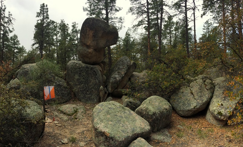
![[image:O flag]](../../Images/Directions.png) WhiteRock event site.
WhiteRock event site.
We will be offering a FREE Beginners' clinic on Saturday AM, beginning at 9 AM. This approximately 1.5 hour course will cover the basics of navigation with map and compass, and follows a short training course through the woods. At completion, beginners
will be ready to try the Sprint courses--an excellent way to reinforce your new skills
We're excited to present two (or three) shorter Sprint courses on Saturday. The Sprints are easy to intermediate difficulty, often relying on strong �handrails� (e.g. trails and streams) to make navigation easier. Each of the Sprints will be less than ~3km in length.
The Sprints are classic courses where participants visit the control points in the order shown on the map. All points must be visited to receive a valid score time. All competitors must be back and checked in by 1 PM. Any arrivals back after 1:10 PM will be scored as a �Did Not Finish.�
For those of you who need a little more excitement, we're offering a Mini-Motala. A Motala is an event that strings two or more individual events together to make a longer endurance event. Participants in the Motala will run all three sprint courses. We will not only record times for each individual event but we'll also record a combined time for all three events.
Schedule:
Registration/check-in opens at 8:30 AM.
Beginners' Clinic begins at 9 AM
Sprint Courses open at 10:30 AM.
Courses close at 1:00 PM.
-
![[image:O flag]](../../Images/Cost.png) Event Fees
.
Event Fees
.
-
Pre-register
. Pre-registration deadline Thursday, May 16 at 11:59 PM. Fees increase for on-site registration.
Night-O
Saturday 18 May 2017, 7:30 PM � 10 PM at the
Big Juniper event site.
This event is intended to provide a less intimidating transition from day orienteering to night orienteering. The Night-O course is just like a Score-O with one main difference - the course occurs at night. Participants have two hours to visit as many destinations as possible. The course is designed so that all destination markers are located close to Thumb Butte road, providing an easy path back to the start if needed. The navigational difficulty is mostly Yellow (easy in the day; intermediate at night.)
We will have a pre-race briefing at 7:50 PM. We'll hand out maps at the briefing, giving you a short amount of time to plan your route. All participants start together (mass start) at 8:00 PM. All competitors must be back and checked in by 10:00 PM. Time penalties apply to those who arrive after 10:00 PM. Any arrivals back after 10:15 will be scored as a �Did Not Finish.�
Schedule:
Registration/check-in opens at 7:30 PM.
Pre-Race Briefing/Distribute Maps at 7:50 PM.
Mass Start at 8:00 PM.
Last time to return without a time penalty: 10:00 PM.
Course closes, participants marked as DNF: 10:15 PM
-
Event Fees
.
-
Pre-register
. Pre-registration deadline Thursday, May 16 at 11:59 PM. Fees increase for on-site registration.
Sunday 4-hour
JOM-O (Spence Creek)
Sunday 19 May 2017, 8:30 AM � 1:00 PM at the
Spence Creek event site.
This is our newest Prescott map area, which features a lot of detail for small reentrants (dry washes), boulders and knolls (small hilltops). The area is filled with lots of small trails and footpaths,
so there will be lots of route choices. With the better-than-normal rainfall last winter, you may even see a bit of flowing water in parts of Spence Creek.
We are excited to be trying out a new format for this 4-hour Score-O. There will be 40 control points located on your map: 20 of them are located along popular bike trails, and 20 of them are located off-trail. You or your team
decide whether to make this an on-trail Bike-O event, a foot orienteering "mini-ROGAINE", or some combination thereof. You will have 4 hours to find as many control points as you can, and the points can be visited in any sequence.
Part of the strategy is to decide which control points to visit on foot, or with the aid of the mountain bike. The penalty for returning past the 4-hour limit is 10 points per minute. Note that the on-trail (Bike-O) control points
are worth fewer points than the off-trail points - so you can be rewarded by venturing off-trail. The color map will be printed on 11" x 17" paper at 1:10,000 scale.
Here are the two approaches for running this course:
1. Running the course as a traditional Bike-O
This course is centered around the newly-completed Spence Basin network of trails. Set in Ponderosa forest, the trails are mostly smooth rolling paths well suited to mountain biking. Because of many parallel and intersecting paths,
this area is ideal for offering many route choice options--the heart of a good Bike-O course.
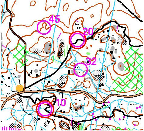
In a traditional Bike-O, all of the control points are located along established trails. There is no need to go off-trail. The challenge for running this type of race is in fast navigating, and in selecting an efficient route
that will earn you the most points in the shortest amount of time. To complete this course, you will need to visit all of the on-trail control points shown on your map. We have highlighted the on-trail control points by using
a double circle around the point (e.g. points 10 and 20 in the figure below). Off-trail control points (45 and 32 in the figure below) are indicated by a single magenta circle around the control point. We will have a special
scoring category for anyone who visits all 20 of the on-trail Bike-O control points. The person or team that completes the course in the shortest time wins. For this event, a "B" level rider or team (that doesn't make significant
navigation errors) should be able to collect all the Bike-O controls in less than 3 hours (a trail distance of ~20 km / 12.5 miles with 1400 feet of climb).
For the more adventurous riders, you can also improve your Bike-O scoring time by visiting some of the off-trail control points that are also shown on your map (designated with a single magenta circle). The time subtracted
from your scoring time is in proportion to the point value for the off-trail control point that you visit--2 minutes will be subtracted for every 10 bonus score-o points you collect. If you navigate well to the off-trail points,
it can help your overall scoring time significantly. If you navigate poorly, your score can get worse...so consider your racing strategy carefully! Please note that per our club rules and the constraints of our permit,
MOUNTAIN BIKES CAN ONLY BE RIDDEN ON DESIGNATED TRAILS or roads, i.e. shown on a map as a thick solid or dashed black line as seen in the figure
above. Bikes can, however, be ported (carried) off-trail or along "social" trails--which can be a useful trick! For more details, see the "Bike-O Scoring category" section in the
JOM-O course description and the mountain biking Rules and Tips.
2. Running the course as mini-ROGAINE (Foot-O) or as an Adventure Race
In this Score-O format, everyone will be scored based on the total points collected, minus any overtime penalties. Scoring is based on point values assigned to the different
controls. Controls assigned a number 10-19 are worth 10 points. Controls 20-29 are worth 20 points. And so on. For this course, points 10 - 29 are all "on-trail" control points for a total of 300 points. The"off-trail"
points 30-49 are worth 700 points, so the the highest possible score is 1000 points.
Control points can be visited in any order, either on foot or with the assistance of a mountain bike. Unlike traditional adventure racing formats, however, YOU DECIDE WHEN AND HOW TO COMBINE FOOT ORIENTEERING WITH BIKE ORIENTEERING.
You can do the whole course on foot, the whole course on a Bike,
or any combination of the two in any order--whatever gets you the most points within the JOM-O course time limit. Please note that per our club MTB rules and the constraints of our permit, MOUNTAIN BIKES CAN ONLY BE RIDDEN ON DESIGNATED
TRAILS or roads, i.e. shown on a map as a thick solid or dashed black line as seen in the figure
above. Bikes can, however, be ported (carried) off-trail or along "social" trails--which can be a useful trick! Bikes can be staged at the start/finish area, and our staff will keep an eye on them.
The estimated straight-line Score-O distance for all 40 controls is 13.7 km with 460m of climb
Schedule:
Registration/check-in opens at 8:30 AM or earlier.
A short course briefing at ~8:40 AM. Maps will be handed out at ~8:45 AM.
Mass start at 9 AM
Course closes at 1:00 PM.
-
Event Fees
.
-
Pre-register
. Pre-registration deadline Thursday, May 16 at 11:59 PM. Fees increase for on-site registration.
Other gear for special events
|
Flashlight and extra batteries (Night-O)
|
Mandatory for Night-O.
|
|
Mountain Bike and Helmet (JOM-O)
|
Wearing a helmet is required for mountain bike orienteering
|
|
Mountain Bike map case or holder (JOM-O)
|
Some method for quickly referencing a map while riding a bike is recommended. See the href="../../Events/GPHXO_MTBRulesAndTips.htm" target="_blank">Rules and Tips.
|
|
Flat pedals / sturdy shoes (JOM-O)
|
--IF-- you will be going off-trail from your mountain bike, it is recommended that you wear sturdy hiking shoes, vs. bike shoes designed for "clipless" pedals.
|
|
A pen and/or highlighter(s) (JOM-O)
|
Recommended for route planning prior to the start of the JOM-O race, especially if you plan to split between orienteering on foot and on a bike (two colors may be useful for this)
|
|
Bicycle repair tools (JOM-O)
|
Be prepared for flat tires or other issues on the trail
|
Primitive Camping
Besides the numerous hotels and campgrounds in the Prescott area, there is limited primitive camping available in designated areas (some are quite close to the Big Juniper and White Rock event sites. See the Prescott National Forest brochure .
Directions
Big Juniper event site.
White Rock event site.
Spence Creek event site.
Fees
|