JROTC Orienteering Meet in PrescottSaturday September 23, 2017
|
This Score-O Orienteering event is located west of Prescott in the basin containing Spence and Willow Creeks. The terrain is primarily Ponderosa forest, with patches of thick brush on the hilltops above the valley floor.
Elevations vary from 5800 - 6200 feet, and temperatures are typically 15 - 20 degrees cooler than Phoenix.
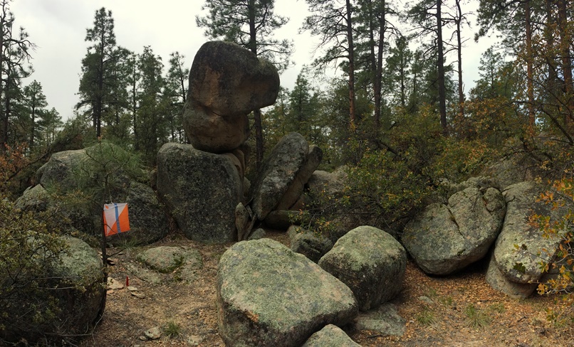
Water may be flowing in Spence Creek. There are also interesting granite rock features that are distributed across the map.
Start times will be begin at 9 AM and the last start time will probably be about 10:30 - 11 AM.
Note: Starting in August of 2017, the Forest Service began converting some of the "social" trails into designated forest trails. This can lead to a lot of confusion on the map
since they are adding new trails, and removing the old ones. We are doing our best to keep current with the changes, but there is a chance that the map may not be up to date.
We will add a new map symbol "trail under construction" and will show the retired trails in light grey for very-recent updates.
The base map used for the competition can be found here
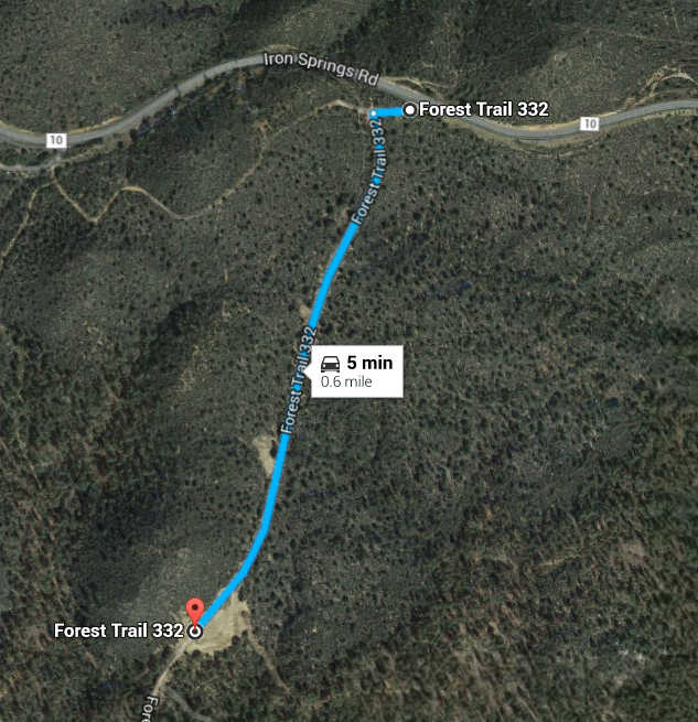
It is about a 90 minute drive from I-17 & Loop 101 in north Phoenix to the turnoff to the event site (see Directions)
Pre-registration allows us to print the correct number of maps, and to minimize updates to the electronic punch database during and after the event. We can, however, accommodate changes and late entries on the day of the event. All fees will be collected the day of the event. The fee is $10 for any team on the Score-O course, and there is a $2/copy printing fee for the Teaching course. You will make life a little easier for us if you complete the pre-registration no later than Thursday Sept. 14.
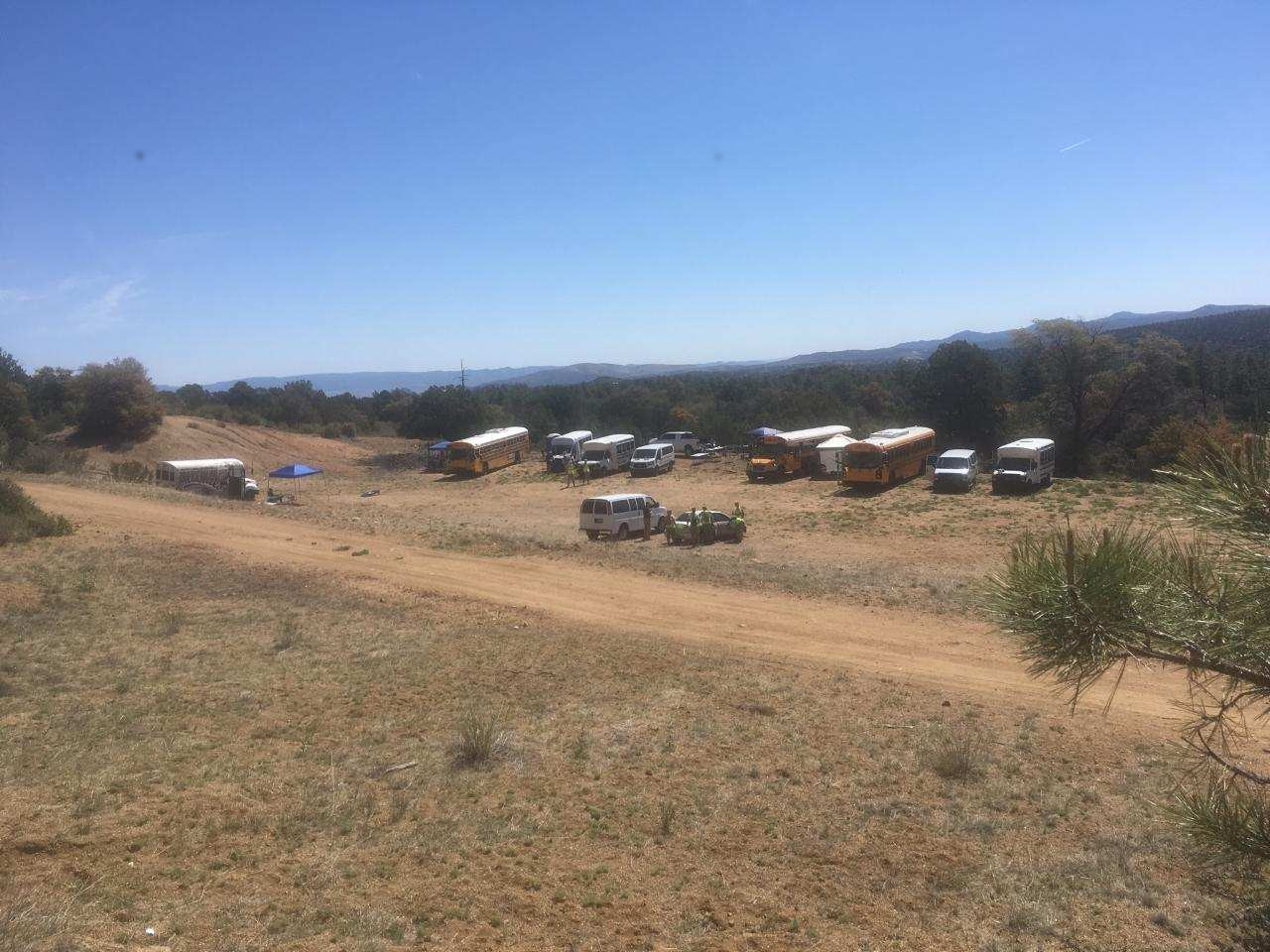
After turning off of the pavement on Iron Springs Road, proceed ~0.6 miles down the dirt road (a JROTC cadet will be attending the gate near the start of the road). The road is passable to school buses. Parking is in a large clearing on the left side of the road. A JROTC cadet will be there to assist in parking
|
|
Check-in/registration is at the large canopy at the south end of the parking area. This is where the instructor will pick up the thumb sticks. The actual start area is located ~250 meters down the road from the parking area (follow the signs). Cadets should take everything that they will need on the course (compass, water, thumb sticks, etc.) before leaving the parking area for the start. The competition and safety maps will be issued at the start area.
Please make your best guess as to how many maps you will want as part of the pre-registration process. You can make modest changes to the number of maps the day of the event.
For the fall event only, a teaching map and course will be available at the Parking/Registration area (NOT at the start table). The printing fee for the two-sided color map is $2 per map. There will be control point markers at each location shown for the course, but there is no electronic punch timing or score keeping. The first few control points are intended to introduce the concept of compass bearings and orienting the map, and later controls allow introduction of map reading and route choice techniques.
The Spence Creek map is a bit different than the other AZ JROTC maps. Although the contour lines are coarser (40 foot), the map has quite a bit more detail on it. The competition maps will be printed in color to make it easier to interpret the finer detail.
First, you�ll see that there are many small blue dashed lines (�shallow water channel�). These are intended to show the fine topographic detail that occur in between the contour lines�that is, they show the dry washes (reentrants). These reentrants can be quite small, perhaps a meter deep. Ridges can be inferred between the blue lines.
Likewise, small hilltops may be shown as a �dot knoll� (brown dot), or using a form line.
Larger topographic features, of course, are visible with the contour lines.
Brush is shown with the green areas. These areas tend to be on top of the hilltops, and can almost always be avoided by staying lower in the valleys, in the pine trees. A shortcut through a green area seldom pays off�it�s pretty thick.
There are many individual boulders and boulder clusters on the map. These are there mostly for the advanced orienteering courses. Only the largest and most distinct boulders will be used for a JROTC course. The description should indicate the height of the boulder if it is used as a control point.
The magenta colored areas are private property and are out-of-bounds.
See the note in the Overview section about new trail construction in this area
More specific information on the base map can be found in the Phoenix Orienteering Map Description (Probably more than you want to know)
1. Trails � Best success is by using the many trails that are in the area. Find an attack point from a trail, and minimize the off-trail distance to the marker. Note that distinct trails are marked differently than indistinct trails. Avoid green areas if possible.
2. Railroad Grade � The Start/Finish is on the railroad grade, not far from the big open area on the map. This road is quite distinctive, with large cuts and fills to preserve the grade. If cadets know how to read the earth bank and cliff symbols (the tick marks always point downhill) then it is easy to tell where the railroad cuts (cliff above road) and fills (cliff or bank below road) are. This is very handy to navigate by, or to use for relocation if confused.
Per the SOP, a secondary safety map is issued to each team. This map is printed at a different scale than the 1:10,000 competition map to provide a larger context for the region surrounding the competition area. This map includes the Safety Bearing, and emergency contact information for the Prescott JROTC leads. The same Safety Bearing and contact information is printed on the reverse side of the competition map
Safety Patrols - A safety vehicle will patrol along the railroad grade and a jeep road to assist teams that need additional water or that need other assistance. In addition, safety cadets will patrol the outer trails to check for teams that may wander off the map.
Water Stops - Unless otherwise indicated on the day of the event, there will be no water stops out on the course. Cadets must bring along enough water for a 2-hour, high activity level event.
Rattlesnakes - It is possible, but unlikely, that a cadet may encounter a rattlesnake on the course. Cadets should receive a briefing on snake encounters before attending this or any other outdoor event. For more details on rattlesnakes in the Prescott area, see this article.
The compettion event is a Score-O, where teams can visit control points in any order. Locations near the start are easier to find, and are worth fewer points. Control points located farther away are harder to find and are worth more points. The first digit of the control number indicates the number of points for that marker. For example, control 44 is worth 4 points, control 23 is worth 2 points, etc.
Each team has 2 hours to complete the course. Penalty points will be assessed at the rate of two (2) points for every minute (or fraction thereof) that a team is over the time limit for a Score-O competition.
Team and School Scoring is per the SOP (electronic punching). Results are usually available mid-week following the event, and will be distributed via email.
The teaching map (autumn event only) is a "classic" (point-to-point) course which is not scored.
Camping is not allowed at the event parking area. Primitive camping in the Prescott National Forest is limited to designated sites. See the Prescott National Forest brochure. The closest primitive camping to the event area are the "FDR 373 Thumb Butte Loop" sites. Click here for a view of and directions to the FDR 51 sites from the brochure. The road up to these campsites is passable to activity buses, but can be quite bumpy and slow.